|
Writer - Philipp Lux The mysterious "Twilight" coral reef was found by a group of divers near the coast of Tahiti. The coral structure was found by a mapping expedition alongside of the island. The Team of divers were swimming at 30 meters depth when they stumbled upon the acres of giant, pristine, rose-shaped corals blossoming at the Twilight zone. The Twilight zone got its nickname for its deep depth, just at the point of the ocean where light still shines. The Reef is a wonder to most marine scientists as these rare corals are in pristine condition when at the depth of 30-70 m depth. Most coral reefs that are present today are being harmed by the heat crisis and waste from humans. Scientist predicts that 70 - 90 % of all corals reefs will be eradicated in the next 20 years due to coral bleaching. Therefore, the marine biologists want to keep this amazing find in the most pristine condition for better marine structure and a hope for further coral growth. With only 25% of the ocean map ranging from 30 to 60 m, it was quite puzzling to find a coral reef that stretched to such a wide depth. Most coral structure only grow to the depth of 30 meters, as there it has the optimal current and sunlight for the best growth. This twilight coral structure just has enough sunlight to be able to continue growing. "We think that deeper reefs may be better protected from global warming," said Laetitia Hédouin, a marine biologist with the French National Centre of Scientific Research and the environmental research centre. The Coral reef will continue to thrive if no harm is done to it. The hope is to find more of these exceptional reefs at 30-70 meter depth, so there is some hope to fight against the coral destruction. For more information: CNN article | Rare Coral Reef : https://edition.cnn.com/2022/01/19/world/coral-reef-tahiti-twilight-zone-climate-scn/index.html 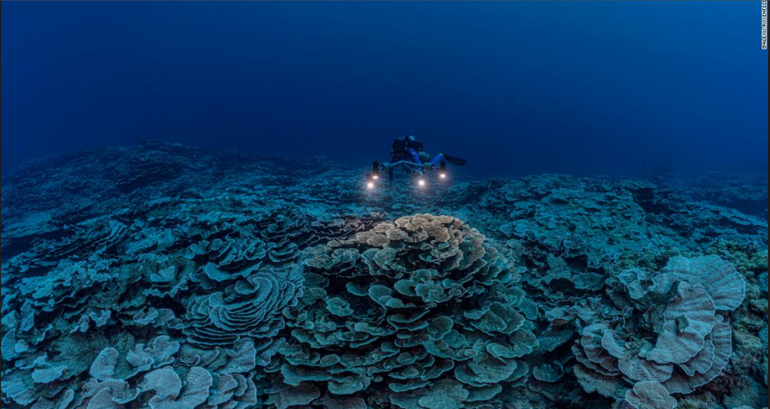
0 Comments
How Autonomous computers will help with mapping the sea bed -Writer - Quinn Sheridan 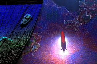 Imagine the long hours it takes to map the seafloor. You need enough fuel to make it where you need to be and back, as well as food and equipment for your crew. Since the ocean floor makes up for 71% of the surface of the earth, this process would take decades. Larry Mayer, the director of the Center for Coastal and Ocean Mapping at the University of New Hampshire has run the calculations and estimates that it would take hundreds of millions of hours to create a detailed map of the ocean floor. So without a different take on the massive achievement, it won’t happen in the next thousand years. With this information, oceanographers have turned to autonomous or self-driving technology drawing inspiration from self-driving cars. By using robotic, wind, and solar-powered boats, Mayer says “you can be out for six, seven months at a time working 24 hours a day. There’s a phenomenal efficiency gain, in terms of the amount of mapping you can do.” So far the ocean has only been 20.6% mapped which, compared to the 2018s figure of 6.9% is a huge achievement. But compared to the amount of Mars we have mapped which is almost 90% it’s feeble. With the large difference between the amount of Mars that is mapped and the ocean, it is becoming increasingly more obvious that we need to focus our attention on the ocean since it could hold much more information than we know. Such as faster trade routes as well as finding new species and learning more about our planet’s underwater ecosystem. This problem can be compared to driving back when there were no street maps as well as no highly accurate GPS. Nowadays it’s hard to understand what are the correct trade routes and travel routes if we don’t know where we are going. The UN saw this problem and took action setting a target date for 2030 for the completion of a detailed 3D image of the ocean floor. “We have a tremendous amount to learn from the automotive industry,” says Mayer, “in terms of the overall technologies of machine learning and situational awareness.” Mayer now works with NOAA and Seabed 2030 to produce the definitive map of the ocean. When mapping out the ocean the oceanographers use two types of autonomous vehicles Autonomous Underwater Vehicles (AUVs) and Unmanned Surface Vessels (USV). The USV can cover a lot more ground but does not have the amount of detail that an AUV has. Unlike Self driving cars AUVs and USVs can not use the light based mapping tools. Instead they have to use lidar for close-range detection, as well as dual-range radar, and 360-degree camera systems. With these AUVs can create perfect high resolution 3D maps. The only problem is the dynamic environments since they do not know what kind of environment they are deploying the ships into.
Sources:
|
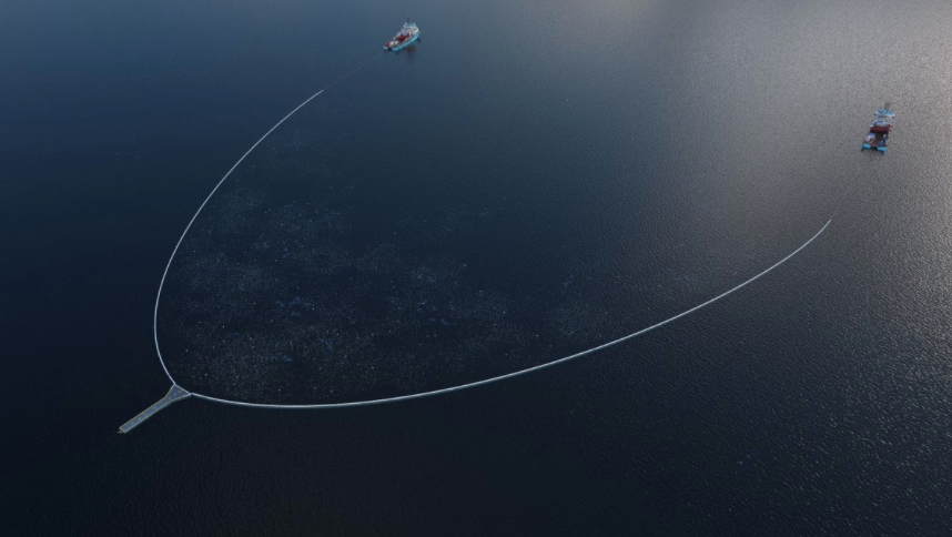 | The current device has been improved multiple times since the original prototype and is essentially an artificial coastline in a 100 m U-shape, that is pulled by two boats at a speed of only 5 knots (less than average walking speed) and funnels garbage into a net. Once it is full, the plastic is collected on the larger boat and taken to shore where it is separated by the team. |
| Some materials are recycled to make products such as sunglasses. The team estimated that it would need about 10 Jennys to clean up the Great Pacific Garbage patch as a single device can hold up to 10,000 - 15,000 kg of plastic. However, there are still major concerns about the efficiency of this device as it can only collect plastic on the surface of the ocean. | 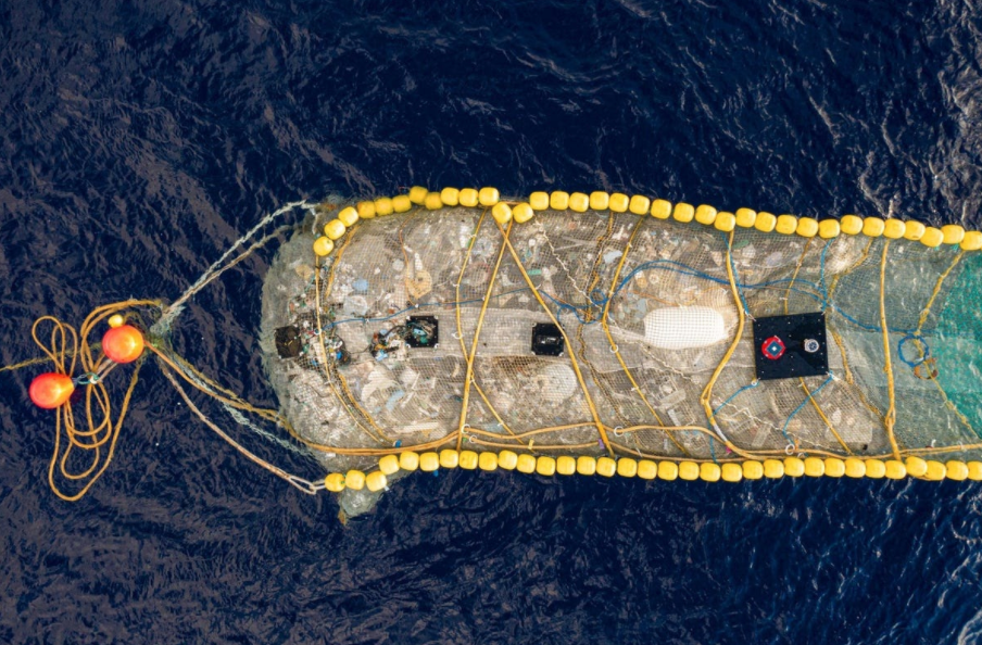 |
Recent studies show that 30 times more of the oceans plastic is found at the bottom of the ocean. Naturally the jenny device does not prevent more plastic from entering the oceans and about 11 million tons are dumped into the ocean per year (Bendix, 2021).
Sources:
Bendix, A. (2021, October 15). A half-mile installation just took 20,000 pounds of plastic out of the Pacific - proof that ocean garbage can be cleaned. Business Insider. Retrieved October 20, 2021, from https://www.businessinsider.com/ocean-cleanup-device-removed-plastic-pacific-garbage-patch-2021-10.
Koop, F. (2021, October 19). This device just cleaned up 9,000 kilograms of trash out of the Ocean. ZME Science. Retrieved October 20, 2021, from https://www.zmescience.com/science/this-device-just-cleaned-up-9000-kilograms-of-trash-out-of-the-ocean/.
Wadden Sea: Home of the Tides
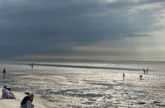
The Wadden Sea is an intertidal region located along the coast connecting the Netherlands, Germany and Denmark. Shaped largely by the tides and sediment deposit, it is a mudflats and sand environment that is largely the size of Kosovo. The flat and coastal wetland is formed by the interactions between the biological factors in the tidal channels, sandy shores and seagrass meadows and the dunes that make up the characteristic landscape of this environment.
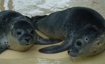
It is the largest unbroken area of its kind and is home to many importing groups of migratory birds and 100 different species of worms and more than 10,000 species of animals and plants. The salt marshes provide support for migratory birds and up to 6 million birds pass through this area each year, which connects the Waddensea to the rest of the global diversity as the birds that nest, and feed in these waters are essential to the worldwide biodiversity of the oceans. The most memorable inhabitants of this coastline that visitors remember are the grey seals, also known as true seals or earless seals, which have become the region's icons and a popular tourist attraction.
The key threats that this environment faces are the development of harbours along the coast and the fishing activities that cause maritime traffic together with tourism developments and impacts from climate change. NGOs working on protecting the natural coastal environment and declaring natural zones are trying to preserve this unique environment. If you ever find yourselves around the northern part of Germany, the Netherlands or the west coast of Denmark, be sure to give this ocean environment a visit!
The key threats that this environment faces are the development of harbours along the coast and the fishing activities that cause maritime traffic together with tourism developments and impacts from climate change. NGOs working on protecting the natural coastal environment and declaring natural zones are trying to preserve this unique environment. If you ever find yourselves around the northern part of Germany, the Netherlands or the west coast of Denmark, be sure to give this ocean environment a visit!
Sources:
Images: Anna Lena Lux
Sources for facts:
Centre, U. N. E. S. C. O. W. H. (2009). Wadden Sea. UNESCO World Heritage Centre. Retrieved October 20, 2021, from https://whc.unesco.org/en/list/1314.
Germany, R. I. (2021). The Wadden Sea – a place of natural and cultural extremes. The Wadden Sea – a place of natural and cultural extremes - Research in Germany. Retrieved October 20, 2021, from https://www.research-in-germany.org/en/infoservice/newsletter/newsletter-2021/june-2021/the-wadden-sea-a-place-of-natural-and-cultural-extremes_livingingermany_.html.
Author
The OMG Newsletter is run by the members of the service group. Topics are taken from the whole world by our researchers and formed into concise articles of our own. We invite experts to bring facts into our educational newsletter, and special contributions of students to showcase their ocean themed comic strip, so that it can be enjoyed by various age groups.
Archives
January 2022
November 2021
October 2021
 RSS Feed
Categories
All
Comics And Art
Fun Facts About The Ocean World
Global News
Local News
NIST OMG News
