
How Autonomous computers will help with mapping the sea bed -Writer - Quinn Sheridan 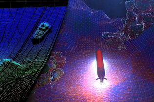 Imagine the long hours it takes to map the seafloor. You need enough fuel to make it where you need to be and back, as well as food and equipment for your crew. Since the ocean floor makes up for 71% of the surface of the earth, this process would take decades. Larry Mayer, the director of the Center for Coastal and Ocean Mapping at the University of New Hampshire has run the calculations and estimates that it would take hundreds of millions of hours to create a detailed map of the ocean floor. So without a different take on the massive achievement, it won’t happen in the next thousand years. With this information, oceanographers have turned to autonomous or self-driving technology drawing inspiration from self-driving cars. By using robotic, wind, and solar-powered boats, Mayer says “you can be out for six, seven months at a time working 24 hours a day. There’s a phenomenal efficiency gain, in terms of the amount of mapping you can do.” So far the ocean has only been 20.6% mapped which, compared to the 2018s figure of 6.9% is a huge achievement. But compared to the amount of Mars we have mapped which is almost 90% it’s feeble. With the large difference between the amount of Mars that is mapped and the ocean, it is becoming increasingly more obvious that we need to focus our attention on the ocean since it could hold much more information than we know. Such as faster trade routes as well as finding new species and learning more about our planet’s underwater ecosystem. This problem can be compared to driving back when there were no street maps as well as no highly accurate GPS. Nowadays it’s hard to understand what are the correct trade routes and travel routes if we don’t know where we are going. The UN saw this problem and took action setting a target date for 2030 for the completion of a detailed 3D image of the ocean floor. “We have a tremendous amount to learn from the automotive industry,” says Mayer, “in terms of the overall technologies of machine learning and situational awareness.” Mayer now works with NOAA and Seabed 2030 to produce the definitive map of the ocean. When mapping out the ocean the oceanographers use two types of autonomous vehicles Autonomous Underwater Vehicles (AUVs) and Unmanned Surface Vessels (USV). The USV can cover a lot more ground but does not have the amount of detail that an AUV has. Unlike Self driving cars AUVs and USVs can not use the light based mapping tools. Instead they have to use lidar for close-range detection, as well as dual-range radar, and 360-degree camera systems. With these AUVs can create perfect high resolution 3D maps. The only problem is the dynamic environments since they do not know what kind of environment they are deploying the ships into.
Sources:
|
AuthorThe OMG Newsletter is run by the members of the service group. Topics are taken from the whole world by our researchers and formed into concise articles of our own. We invite experts to bring facts into our educational newsletter, and special contributions of students to showcase their ocean themed comic strip, so that it can be enjoyed by various age groups. Archives
January 2022
Categories
All
|
 RSS Feed
